
Arrive early at Zion National Park for the best parking. There’s a hike for all skill levels here and a mandatory shuttle that takes you to all of the points of interest.
Zion National Park Highlights on Friday, September 1, 2017
- Emerald Pools
- Riverwalk Trail
- Watchman Trail
- Weeping Rock
- Court of the Patriarch
Zion National Park is an easy two hour drive from Bryce National Park. We arrived before the 7 am sunrise and as we drove the windy road came across two big horned sheep crossing the road before the tunnel. I was lucky enough to whip out my iPhone fast enough to catch a video! Similar to Bryce Canyon, Zion costs $30 per car and is tied for the most expensive Utah national park (buy the Annual National Park Pass). Unlike the other parks, Zion has a mandatory shuttle that takes approximately 80 minutes to complete a full loop. If you’re like us and arrive super early, you’ll be able to find a parking spot in the park. We parked on the main path by the Canyon Junction shuttle stop (#3). If you want to see the shuttle route, check out this site: https://www.nps.gov/zion/planyourvisit/upload/MG-Spring-2017-ZION-WEB.pdf
After parking, we walked along the Virgin River for a little bit. There’s a wide paved path along the river where you can take beautiful pictures, see unique bugs and catch the morning bikers go by.  From here we took the shuttle from Canyon Junction (#3) to Zion Lodge (#5). We went to the road and followed the signs to the Emerald Pools. The walk is quite steep and the lower and upper falls were our favorite. When you leave the middle level emerald pool, take the Kayenta Trail. This will take you to the Grotto (#6) and gives you fabulous views of the Virgin River.
  Keep your eyes peeled – we looked down at the river and spotted a deer standing in the water taking a drink. We saw tons of wild turkey at the Grotto. There’s also a place to fill up your water bottles and use the facilities here. If you’re up for the challenge, you can complete the strenuous hike up Angel’s Landing.
As it neared lunchtime, we took the shuttle to the last stop, the Temple of Sinawava (#9). There are lots of places to sit here and eat lunch, just be weary of the squirrels trying to steal your food. The Riverside Walk is a paved and easy two mile round-trip walk that starts here. The walk ends at the Narrows, which looks beyond incredible if the weather is right. If you’re considering this as part of your adventure, I would recommend this site which offers the appropriate rental gear.
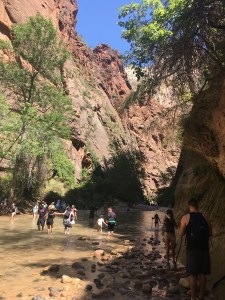
It seemed like everyone we saw was wearing the Adidas hydro lace canyoneering boots and had hiking poles* to keep steady while wading through the water.
We needed a break to catch our breath so we took the shuttle to the Visitor Center (#1). If you haven’t gotten a park map and newspaper yet, this is a chance to get them. It was nice to sit in the air conditioning, eat our snacks and re-hydrate. From the Visitor Center, we walked to the Watchman trailhead. This hike has many switchbacks and limited shade in the afternoon, but it quickly became our favorite hike of the day. We saw lots of birds, butterflies and the views from the top are unmatched. When you reach the top, there’s a sign that points to an extra loop – take it! You won’t regret it.  Considering it was the heat of the day when we hiked, we didn’t see many others on this trail, but we got lucky at the end and saw a grey fox!
Thankfully, the continuous shuttle gives you the opportunity to see almost everything along the main path. We took the shuttle to Weeping Rock (#7). It’s an extremely steep climb, but probably takes less than 45 minutes round-trip and is a cool point of interest. From here we took the shuttle to the Court of the Patriarchs (#4) and found another easy to see point of interest. The three sandstone peaks are named Abraham, Isaac and Jacob. You can read more about them at the viewpoint or hear about them on the narrated shuttle ride.
As the day neared sunset, we headed back to Canyon Junction (#3) to watch the sunset with others along the bridge over the Virgin River. Like the other national parks, watching the lighting change on the oversized sandstone rocks is a site worth photographing. We made the drive out of Zion National Park and were lucky to find a last minute deal through Booking.com for Sun-n-Sand Motel about 35 minutes away and in the direction of the Grand Canyon. I love Booking.com because you can make your reservation and pay once you arrive. If you use my link to make a booking, we’ll each get $20. We were lucky to book the motel for under $80. The motel was nice, clean and offered a free breakfast (think cereal, donuts, coffee, etc.). It’s also in a little town called Kanab that offers a grocery store called Glazier’s Market and gas stations.
Wake up with us tomorrow at the North Rim of the Grand Canyon, our fifth of seven national parks.

 Before making a stop, the park doesn’t appear to be that impressive. It’s probably because you don’t realize you’re driving along a canyon until you actually pull into a parking lot and look over the edge. As we continued toward the end of the road to see Rainbow Point, we pulled into the lots at Aqua Point and Ponderosa Point to take in these views. If you have the better part of a day and don’t plan on doing extensive hiking, you’ll have time to stop at each point of interest.
 Make sure to take some time to hike here. An easy, short trail is the Bristlecone Loop which is about 1 mile. If you’re lucky, you’ll see a Peregrine Falcon diving into the canyon (we were not). We did, however, see some of the largest ravens we’ve ever seen searching the picnic grounds for scraps.
 Hoodoos are the skinny and tall rock formations that you see everywhere at this park. The walk along the rim in the direction of Inspiration Point is definitely worth it. There is so much to take in at this particular stop. If you’re short on time, drive to Inspiration Point (or take the shuttle). We arrived to two deer grazing here and then headed to the rim to see the sun hitting the red rocks. If you’re up for the challenge, climb the steep hill to get the best vantage point from the top. While we did not use
  To end our time at Bryce Canyon National Park, we parked at Sunset Point. The walk between Sunset Point and Sunrise Point is incredible. If you have the right shoes and are up for the challenge, take a hike into the canyon. We enjoyed walking the rim of the canyon, spotting the pretty blue birds and watching the sun start to set and illuminate the rocks. We also spotted Thor’s Hammer, which is one of the better known and photographed hoodoos. As we awaited the sunset, fancy photographers gathered to find the best spots to capture the lighting change as the sun went down.


 The way the light hits the colorful rocks is incredible. A bit farther up the road, which is windy, rocky and narrow, we made it to a small parking lot by Goosenecks Overlook and Sunset Point. The Goosenecks Overlook was our first time looking into a canyon and it is breathtaking.
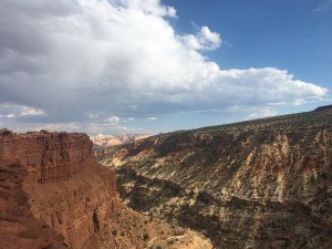
 We had to drive very carefully as we saw many deer along the road near the campsites. It is cool to reflect that we ended up seeing deer at six out of the seven national parks that we visited during our vacation. We drove along the Scenic Drive until we made it to the signs that read Capitol Gorge. We didn’t exactly know what we were in for either. This is an extremely narrow and scary drive.
 The beginning of the hike is very easy and relatively flat along the river. Then there is quite a steep climb before reaching a point before you then start walking down again. We saw lots of playful chipmunks and a few amphibians, but no snakes thankfully! The arch is awesome once you arrive. Enjoy calling out so you can hear your voice echo back. Once you go under the arch, we found it challenging to find and stay on the path, but fortunately made it around the loop as the sign recommended (counterclockwise direction).

 If you arrive before the park opens, there’s no one at the gate, however, if you plan on seeing multiple National Parks, it’s worth spending the $80 to get the
  One benefit of starting early is you’re likely to beat the tour busses that are bound to come and stop at these points of interest. Balanced Rock is perfect for taking a short stroll and stretching your legs from the car ride.
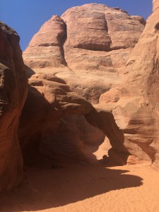


 This little trailer coffee shop offered delicious iced lattes with unique flavor combinations.
 favorite. While driving around, we were fortunate to see a few horses at two different camp sites as well as a deer (one of the campsites is the one across from the Life of the Marsh parking lot).
 We found parking to be quite a challenge, so make sure to pack your patience. Ocean City has a
 While almost everything was closed, the “Island Creamery” ice cream shop had a huge line! It was fun to window shop the antique stores, look at the home sale flyers and notice the cute coffee shops like “On What Grounds?” on the main street. After we got our steps in (yep, we counted them on the Garmin and got over 36,000; Mike got 40,214 with his run) we were ready to call it a night.
 After taking in the sunrise, make sure to jump back in your car and continue along the main street. We got to the roundabout and saw four ponies and then on our way out saw at least 10 more. Again, have your camera ready!
  Having taken it all in, we decided to drive to Salisbury, Maryland to check out this small town. If you decide to roll through this small town, I highly recommend a stop in (or drive thru) to Rise Up Coffee. Their seasonal lavender latte was delicious! We drove by and saw the beautiful campus of Salisbury University while we waited for the free Salisbury Zoo to open. The zoo is very small, but if you’re zoo people like us, that won’t deter you from at least checking it out. The macaws were funny to watch flip around on their rope. Hopefully if you go, more of the cool animals like the sloth and jaguar will be out and about.
 Make sure to wear your walking shoes, because the zoo is a bit spread out, yet relatively easy to traverse and see everything without really having to retrace your steps. Also, there’s an indoor wildlife area where you actually leave the entrance to the zoo as if you’re heading to the parking lot and enter the botanical gardens which you don’t want to miss. Some of the highlights included the:
 didn’t want to spend $15 or $20 on parking for a few hours. Once you arrive to the park, there are kiosks as well as the normal will call area where you can buy tickets from a salesperson if you don’t find a good deal for tickets ahead of time.
  As with any baseball park, make sure to spend time walking around to check out the statues, different views of the city and other nuances. The night we went the Frank Robinson statue was unveiled as part of Heritage Park. It’s also fun if you can spot or get a picture with Slider, the pink bird looking mascot for the Cleveland Indians.
 We did this because it’s a small parking lot that tends to fill up fast. It’s definitely worth walking along the boardwalk and stairs to get relatively close to the waterfalls to take some pictures. There are also lots of nice trails (paved and unpaved) to walk along. If you’re on the unpaved paths, make sure to bring your hiking boots in case it’s muddy. I love my
  beautiful big rocks and like the woman at the Visitor Center told me, has a feel like something out of Jurassic Park. Take a big loop around after jumping from big rock to big rock at the overlook. Take some goofy pictures peeking out from behind the rocks or like you’re falling off the rocks. Well, there you have it, our weekend in Cleveland and Cuyahoga Valley National Park.